
Recreating the Historic Landscape of 1862
The visualizations presented on this website are the result of extensive research and collaboration by researchers at the Center for Advanced Spatial Technologies and park officials at Prairie Grove Battlefield State Park. Information was compiled from multiple sources including historic maps of the area, civilian accounts, and published books and manuscripts to create a holistic view of how the landscape may have looked in 1862. The result is the numerous images of the historic landscape and structures of 1862 found throughout this website.
This section discusses the process of creating the 3D landscape where the Battle of Prairie Grove took place in 1862. A lot of decisions are made when recreating an environment in 3D. For example, how were the houses constructed and what did they look like? For most of the houses in the immediate battle area, brief descriptions are provided in soldiers written accounts. The William Rogers house for example was described as a “square two story building that was painted white” while the Morton house had photos available that were taken in the 1890's (Fields of Blood, 146). These resources were instrumental in creating 3D models of all of the homes in the battle area. In addition to the homes themselves, each homestead typically included “an orchard, garden, woodpile, barn, springhouse, smokehouse, chicken coop, corncrib and assortment of sheds, workshops, and fences.” (Fields of Blood, 146). This document discusses the process of creating all of the elements of the 3D battlefield landscape including the terrain, vegetation, homes, and more.
Creating the Historic Landscape
The base maps and the terrain
The base map for the 1862 landscape is an historic parcel map of the area from 1894. The collection of eleven parcel maps known as the Skelton maps represent the first systematic survey of Washington County, Arkansas completed by Gordon V. Skelton. While there is a 30 year difference between the parcel maps and the date of the battle, it is believed that the rural landscape around Prairie Grove was not significantly altered in the late 1800's. The parcel maps were scanned by Tom Maringer and made public in 1998. The maps are named in accordance with the Public Land Survey System (Section/Township/Range) which made them easy to geo-locate.
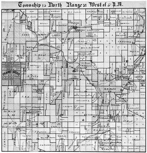
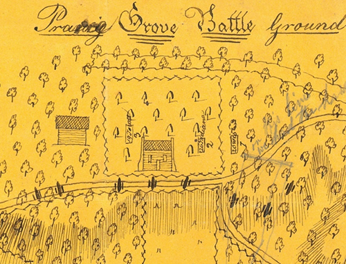
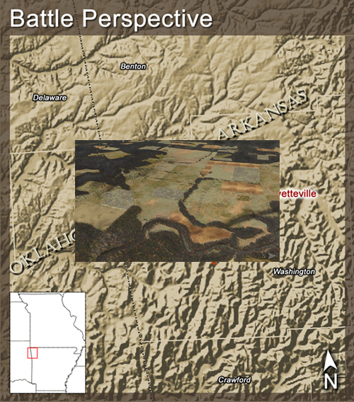
For this project, nine of the maps around the Prairie Grove area were georeferenced in ArcMap GIS software. From these maps, a regional map was clipped and created centered on the Prairie Grove area (11.5 miles by 9 miles). The regional map was then combined with a more detailed map of the immediate battlefield area supplied by Arkansas State Parks (shown below).
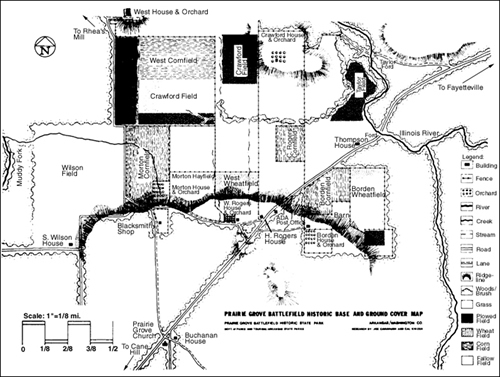
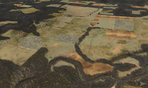
The map titled “Prairie Grove Battlefield Historic Base and Ground Cover Map” was the primary source for identifying and locating features including houses, fences, rivers, roads, fields, forests and more within the battlefield area. In areas where there were discrepancies between the state parks map and the Skelton map, preference was given to the state parks map.
The following is a description of the landscape from Shea's Fields of Blood:
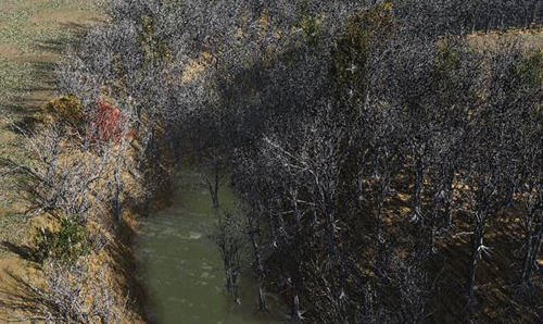
Below Herron's position on east bluff, the Illinois River flows north through a well-defined flood plain incised into the limestone surface of the Ozark Plateau. At the time of the Civil War the narrow plain was covered with a forest of oak, hickory, cedar, poplar, and elm. West of the river is Crawford's Prairie, a broad valley one and a half miles long from east to west and three-quarter of a mile wide from north to south. In 1862 roughly half of the valley floor was still covered with native grasses and used as pasturage; the other half was planted in corn and wheat. Miles of split-rail fences enclosed large rectangular fields that gave the valley floor the appearance of an irregular checkerboard.
Terrain data was created from a 5-meter resolution digital elevation map. The elevation data were based off of the 2006 5-meter resolution LIDAR dataset for Washington County. The terrain layer was clipped to match the extent of the regional map and was imported directly into the Vue Infinite software using the .dem format. The terrain in Vue was exaggerated by a factor of two to show relief details in the battle proper area.
Designing the Ecosystems in Vue
Ecosystem layers were created for the different land use types that were designated on the base maps shown above. Ecosystems were created for forests, wheat fields, corn fields, fallow fields, plowed fields, orchards, and roads.
The forests of the area were described by Shea in the following excerpt:
For most of the nineteenth century Prairie Grove was covered with an extension of the hardwood forest that filled the flood plain of the Illinois. A longtime resident wrote that the thicket atop the hill was so dense a “man on horseback could only be seen at intervals.” One of the peculiarities of an Ozark forest is that several species of trees retain their desiccated foliage through the winter. Consequently, the woods on and around Prairie Grove provided soldiers in both armies with a measure of concealment even in December.
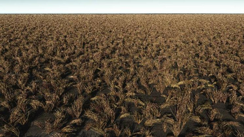
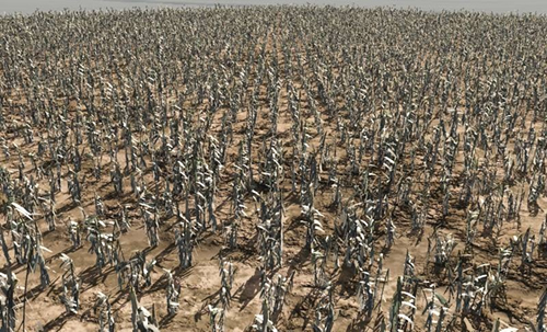
The corn and wheat fields of the area would have been harvested in the previous fall. Wheat fields were presumed to have not been planted in rows and to have been cut or harvested only to leave the stalk of the plant. Several Union accounts state that the wheat fields were covered with stubble about six inches high at the time of battle.
It was common practice in the mid-19th century throughout the Midwest to leave corn stalks standing in a field throughout winter. Shea writes:
Southern farmers of that day usually left their corn standing after the harvest, and Archibald Borden was no exception. His two cornfields were filled with withered stalks tall and thick enough to hide a line of infantry.
He continues:
Fagan, like Shoup, found it difficult to determine the strength and direction of the Union assault. Distance, smoke and the “high weeds of the prairie” (not to mention cornstalks) masked the advancing blue lines even before they entered the visual shadow and disappeared from view.
A fallow field is a field that has been left unseeded and is left to its own natural growth. All fallow fields were depicted with a scrubby undergrowth and with occasional tall weeds and grasses.
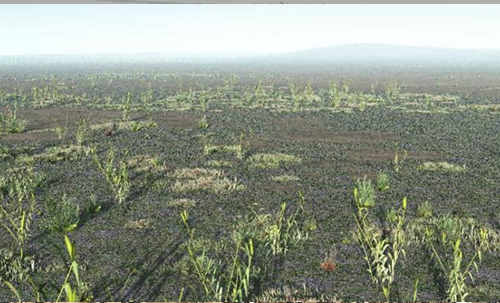
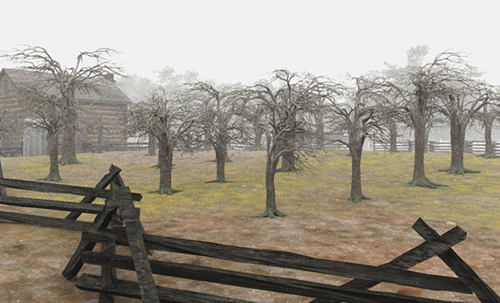
Plowed fields were shown with alternating rows of plowed dirt. The fields would have probably been plowed with horse or oxen-drawn plows or possibly hand-tilled. Orchards were shown with rows of apple trees in leaf-off conditions. Orchards in the Ozarks in the late 1800's were typically either fruit or nut orchards. Apple orchards were chosen for the orchards in and around Prairie Grove.
The Structures
The descriptions for most of the houses depicted on the battlefield landscape were taken from Shea's book and from civilian accounts. Shea writes:
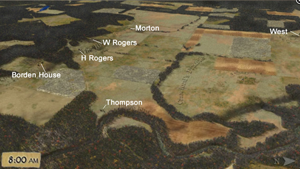
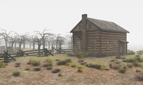
Four houses were scattered along the north side of Prairie Grove. On the east was the Archibald Borden home; perched eighty feet above the valley floor atop the steepest part of the Ridge, the two-story yellow house was the most visible structure on the battlefield. The one-story William Morton home, three-quarters of a mile to the west, was more modest, but it had a cellar that would serve as a place of refuge in the storm to come. Midway between the Borden and Morton residences were the Hugh Rogers and William Rogers homes, the former a one-story L-shaped structure, the latter a square two-story building. Both were painted white and located on a natural bench or terrace near the foot of the hill….The West home sat atop a slight eminence known as West's Knoll, which offered a spectacular view of the valley.
Shea continues:
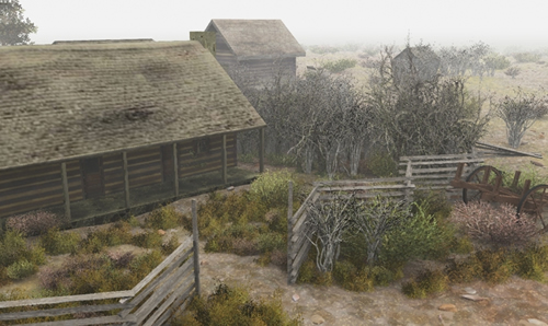
All of the “fine old fashioned farm houses” at Prairie Grove were built of squared logs, though some, like the Borden house, had been improved by the addition of weatherboarding and paint. “Everything about them [was] as cozy and comfortable as heart could wish,” wrote a Kansas soldier. Each homestead typically included an orchard, garden, woodpile, barn, springhouse, smokehouse, chicken coop, corncrib and assortment of sheds, workshops, and fences.
The houses were placed on the 3D landscape using the Arkansas State Parks map as a guide. In addition to the houses, additional outbuildings including barns, outhouses, wells, springhouses, and sheds were also included on all of the homesteads. The location of the homes within the 3D landscape can be seen on the image below. Note the camera perspective is looking southwest across the Illinois River.
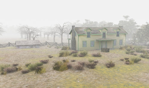
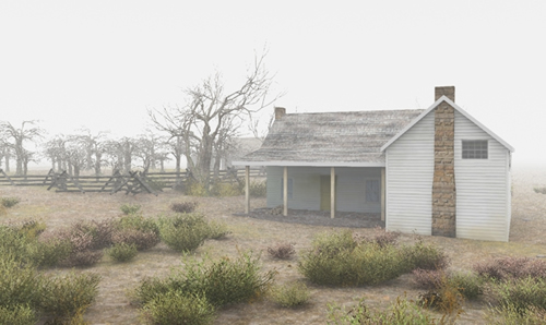
The Borden House
The Borden house was one of four that was burnt the day after the battle. The house was rebuilt by Archibald Borden several years later and is reported by Caldonia Ann Borden to “have closely resembled the original.” The rebuilt home is still located at Prairie Grove Battlefield State Park today and was the basis for the 3D model of the Borden home. The house was given green trim based on the following passage from Caldonia Borden:
Our beautiful two-story house that was painted light yellow with green trim, the home that we all loved so much, had been burned to the ground after the Yankees plundered the inside…
In addition to the home itself, a large barn was also on the property and was located east of the home according to a hand drawn map drawn by soldier DB Arthur.
Final renderings of the Borden house and associated structures can be seen below:
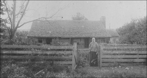
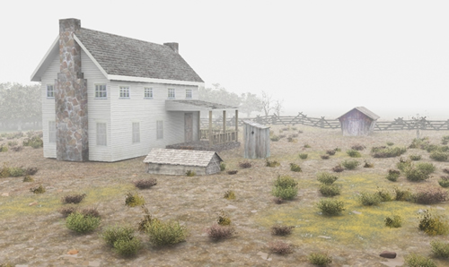
Morton House
The Morton home and cellar was where families from the surrounding area took shelter during the battle. The Morton house survived the battle and several pictures of the home were taken in 1911. These pictures were the primary source of information for the 3D model of the Morton home. One of the pictures compared with a 3D rendering of the Morton home can be seen below.
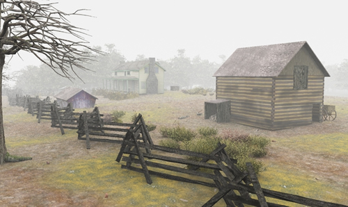
Will Rogers and Hugh Rogers Homes
Less information is known about the Rogers' homes. They are described in Shea's account above:
Midway between the Borden and Morton residences were the Hugh Rogers and William Rogers homes, the former a one-story L-shaped structure, the latter a square two-story building. Both were painted white and located on a natural bench or terrace near the foot of the hill.
William Rogers home was burnt to the ground the day after the battle and Hugh Rogers house survived the battle and served as Union headquarters for General Herron and his men.
Final renderings of Hugh Rogers and William Rogers homes can be seen below:
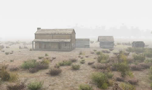
Thompson House and West House
Little is known about the Thompson and West homes. The Thompson house was located where Fayetteville Road crosses the Illinois River and the West house was located on a knoll in the Northwest section of the battlefield. Both survived the battle and were described as “two-story log structures.” Renderings of the Thompson house and West house are provided below.
Fences
Split rail fences were used as property boundaries throughout Prairie Grove. A split rail fence is constructed out of logs that are split lengthwise and stacked together. The one's shown in the battlefield visualizations are shown with supports and were constructed to be 3-4 feet tall.
The Viewpoint for the Battle
The historic battlefield landscape is completely 3D however for depicting the battle events a single 2D perspective was chosen. The birds-eye view of the battlegrounds is from the northeast and is focused on the ridge where the Confederate troops established position. All important landmarks including the ridge, the Illinois River, Crawfords Prairie, and significant structures in the battle area were included within the frame. Labels were added to the final perspective image to help orient the user.
Why aren't there any people?
At the onset of the project, it was decided that human elements would not be used in the visualizations. The purpose of this project was to showcase the historic battlefield landscape and how the battle unfolded within the landscape. Prairie Grove is fairly unique in that it is one of the few remaining battlefields in the nation with land use closely resembling what it was during the Civil War. However over 95% of the battlefield is privately owned and numerous structures including chicken houses, homes and outbuildings have been constructed on the battlefield. By recreating the historic battlefield landscape in 3D we have illustrated how similar the historic landscape is to the modern landscape. We have also eliminated the modern development of the landscape and have reintroduced historic elements that no longer exist.
Project Software
Several software packages were used in creating the 3D visualizations of the Prairie Grove battlefield. Vue Infinite was the primary landscape visualization package. All terrain and building models were imported into Vue where realistic vegetation and atmospheric conditions were added. All final images shown on this site were rendered out of Vue.
In addition, Google Sketch-Up was used to model and texture all of the 3D structures on the landscape including the houses, outbuildings, and fences. All models from Sketch-Up were imported with textures directly into Vue using the .3DS format. Adobe Photoshop was integral in creating all of the image textures for the 3D models.
ArcGIS was used to compile all of the map information associated with the site including the 3D terrain data. Maps and terrain were exported out of ArcGIS and brought into Vue.
Bibliography
Shea, William L. Fields of Blood: The Prairie Grove Campaign. Chapel Hill: The University of North Carolina Press, 2009. Print.
Shea, William L. “Thunder in the Ozarks: The Battle of Prairie Grove.” North & South June 2006: 12-23. Print.